Indigenous · History Classes · Grades 10–13 · College · University
The Steppe World — Scythians, Khans, and the Thousand Years of Tartary
History Class · Level band: Grades 10–13 · College · University
English edition — the language editions of the history classes are outstanding and will follow the site’s translation pattern; none is fabricated here.
§1 — THE GRASSLAND ITSELF
DOCUMENTED. Between the forests of the north and the deserts and farmed empires of the south, a single band of grass runs almost unbroken from Hungary to Manchuria — some eight thousand kilometres of open country where rain is too scant for reliable ploughing and grass is too rich to waste. On that grass a way of life fitted itself exactly: herds of sheep, cattle and above all horses, moved season by season; homes that moved with the herds — the felt tent, the wagon-house; wealth counted in animals; skill counted in the saddle. Settled empires ringed the steppe on every side — China, Persia, Rome and later Byzantium, the Rus' principalities, the caliphates — and for more than two thousand years the peoples of the grass were their neighbours, their traders, their mercenaries, their raiders and, again and again, their conquerors. The history of the steppe is not a footnote to the history of those empires. For long centuries it was the larger half of the story, and the empires knew it: China built the greatest wall on earth facing it.
§2 — THE SCYTHIANS IN HERODOTUS
DOCUMENTED — the first full portrait. The earliest extended account of a steppe people that survives is Herodotus's fourth book (written c. 440 BC), on the Scythians of the Pontic steppe, north of the Black Sea. Herodotus travelled, asked, and recorded — including what the Scythians told about themselves. Their own account made them the youngest of peoples, a thousand years old by their reckoning: Targitaus, a son of Zeus and of a daughter of the river Borysthenes, had three sons, and to them fell from heaven golden things — a plough and yoke, a battle-axe, and a cup — which burned when the two elder brothers approached and cooled for the youngest, Kolaxais, who took them and the kingship. Herodotus also records a Greek version, and gives his own judgment plainly: he does not believe either tale entire, but holds that the Scythians came originally from Asia, pressed westward by the Massagetae. The three accounts stand in his book side by side — the people's own, the colonists', and the historian's.
DOCUMENTED — a people with no cities. Herodotus's Scythians had neither cities nor fortified places; they carried their houses with them, lived from their cattle, and fought as mounted archers — in his summary of their one great invention, they had arranged matters so that no invader could catch them and none could escape them: since they have no cities or forts, and carry their houses with them, and are all archers on horseback, and live not by ploughing but by herds, and their dwellings are on wagons, how should they not be invincible and unapproachable? Nomad Scythians, ploughing Scythians who grew grain for export to the Greek ports, and Royal Scythians who held the rest as their subjects divide his account.
DOCUMENTED — the royal burials, and the hemp vapour. When a king died, Herodotus describes the body embalmed, carried in a wagon on a circuit of the subject peoples, and laid in the great burial ground at Gerrhi in a square pit — with a strangled concubine, cupbearer, cook, groom, servant and messenger, horses, and first-fruits of his goods, a mound heaped high over all; and a year later a further rite of fifty strangled attendants and fifty horses set as a mounted guard around the tomb. The kurgans of the Pontic and Altai steppes, excavated in the modern record with their gold work and sacrificed horses, stand behind his description in material fact. After a burial, he says, the Scythians purified themselves not with water but with vapour: a small felt tent on three sticks, red-hot stones in a dish, hemp-seed thrown on the stones, and the Scythians inside, howling with pleasure at the steam. The frozen tombs of Pazyryk in the Altai yielded the apparatus itself — the tent poles, the censer, the hemp seeds — a traveller's tale confirmed by the ground two and a half millennia later.
DOCUMENTED — the answer to Darius. About 513 BC Darius of Persia crossed into Scythia with an army and a bridge of boats over the Danube. The Scythians refused battle, drew him deeper, burned the grass and fouled the wells before him, and answered his demand that they either fight or submit with the message of their king Idanthyrsus: they had no cities and no cultivated fields for whose sake they need fear or fight; if the Persians wanted battle, let them find and violate the tombs of the Scythian fathers, and then learn whether the Scythians would fight; and as for Darius calling himself their master — “I say to thee, ‘Go weep.’” At the end, with Darius worn down, the Scythian kings sent his herald's answer in objects: a bird, a mouse, a frog, and five arrows. Darius read surrender in them; his counsellor Gobryas read the truth: unless you Persians become birds and fly into the sky, or mice and hide in the earth, or frogs and leap into the lakes, you will be shot by these arrows and never return home. Darius withdrew by night. The steppe had made its standing argument for the first time in the written record — that there was nothing there to capture, and that an empire which marched in would find only distance, hunger, and archers — and it would make the same argument, in the same way, for two thousand years.
§3 — THE HUNS, AND THE XIONGNU QUESTION
DOCUMENTED. On the eastern steppe the Chinese record names the Xiongnu: a great confederation gathered under Modu Chanyu from 209 BC, masters of the Mongolian steppe for three centuries, treated with by Han China in tribute, trade and marriage alliances, and at war with her as often. On the western steppe, in the 370s AD, the Huns appear in Roman sources crossing the Volga, breaking the Alans and the Goths, and within two generations standing under Attila (r. 434–453) at the centre of a steppe empire in Hungary that drew tribute from both Roman empires and marched into Gaul and Italy.
DEBATED — the link between them. That the Huns were the Xiongnu come west — first proposed in the eighteenth century — remains a live dispute. For the link: the name's resemblance through Sogdian and Chinese transcriptions; Central Asian sources that translate the one name by the other; near-identical bronze cauldrons buried in like fashion from the Ordos to Hungary; and recent archaeogenetic work finding direct connections between Xiongnu-period elites in Mongolia and some Hunnic-period burials in the Carpathian Basin. Against a simple identity: a gap of some two centuries and thousands of kilometres with almost no written record between them; the Huns' own near-total silence — they left practically no written record of themselves; and the mixed character of every great steppe confederation, which gathered peoples of many languages under one ruling name, so that continuity of a name or of part of a population is not identity of a whole people. The record supports a connection argued for and against by serious scholarship; it does not support either certainty.
DOCUMENTED. What is not debated is the pattern both powers exhibit: a confederation, not a nation — many peoples under one khan's or chanyu's peace, held by success, tribute and fear, and dissolving when the success failed. Attila's empire did not outlive him by a generation. The steppe's states were real, and formidable, and mortal.
§4 — THE TURKIC KHAGANATES
DOCUMENTED. In 552 Bumin, of the Ashina clan of the Türk, overthrew the Rouran khaganate and founded the First Turkic Khaganate — the first steppe empire to leave its own words in stone. Within a generation it stretched from Manchuria to the Black Sea, dealt with Persia and Byzantium as an equal — a Sogdian-led embassy reached Constantinople in 568 — and split, by the early 580s, into eastern and western wings. The Eastern khaganate fell to Tang China in 630, rose again in 682, and in the 730s raised the great runic inscriptions of the Orkhon valley — the memorials of Bilge Khagan and his brother Kül Tigin, and the counsels of the adviser Tonyukuk — in which the khagans speak in the first person to their own people about how the steppe is won, held, and lost: the earliest literature of the steppe written by the steppe. The Western khaganate dissolved into successor peoples — Khazars on the Volga and the Caspian, who held a trading empire there for three centuries; Bulgars, who carried the name to the Danube and the middle Volga; Türgesh, Karluks, and the Uyghur Khaganate (744–840), which built the steppe's first true nomad capital at Ordu-Baliq. From these centuries the Turkic languages spread across the whole grassland, and they are the linguistic ground of most of its peoples today.
§5 — 1206 AND THE MONGOL ORDER
DOCUMENTED. In 1206, at a kuriltai by the Onon river, the Mongol clans acclaimed Temüjin as Chinggis Khan, and the peoples of the felt-walled tents became one people under one law. The conquests followed — northern China, the Khwarazmian empire destroyed 1219–21, the Rus' principalities and Hungary entered 1237–42 — but the conquests are only half of the record. The other half is the order.
DOCUMENTED — the law. The Yassa, Chinggis's great ordinance, bound Mongol and subject alike: it outlawed the theft and raiding that had made the steppe ungovernable, suppressed the blood-feud, fixed penalties — restitution multiplied, death for horse-theft and murder — and protected envoys absolutely. No complete text of it survives; its provisions are known from the Persian, Armenian, Arabic and Chinese writers who lived under it — a gap owed, and named here as such.
DOCUMENTED — the yam. Systematised under Ögedei from the 1230s, the yam was a relay empire-wide: stations a day's ride apart — some twenty-five to thirty miles — each stocked with fresh horses, fodder, food and lodging, served by station households, and used by couriers and by travellers carrying the khan's tablet of authority, the paiza. At its fullest the network counted its horses in the tens of thousands across thousands of posts from Korea to Hungary; an urgent dispatch crossed in weeks what had taken caravans a season. It was the nervous system that made governing a continent possible at all.
DOCUMENTED — the religious settlement, and the Pax. The Mongol court practised a deliberate toleration: the khans exempted clergy of every faith from tax and service and set the faiths debating before them — at Möngke's court in 1254 the Franciscan Rubruck disputed with Muslims and Buddhists in a formal disputation the khan himself ordered. Nestorian Christians, Muslims, Buddhists, Daoists, Confucians and the steppe's own tradition all stood inside the empire's peace. Under that peace — the Pax Mongolica — the roads of Eurasia were, by the testimony of the merchants who used them, safer than they had ever been: partnerships joined Mongol capital to Muslim and Uyghur merchants; paper money, relay passports and protected caravanserais carried Chinese silk and porcelain west and European and Persian goods east. The same roads also carried what no one chose: the plague that reached the Black Sea in the 1340s travelled the Pax's own arteries — the standing reminder that a connected world shares everything it carries.
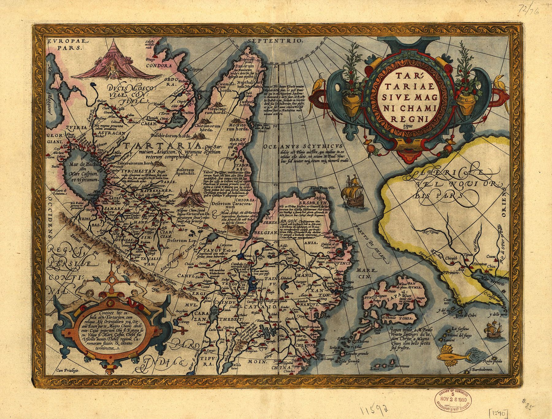
The steppe world as Antwerp drew it, 1570.
Maker: Abraham Ortelius, Antwerp · Date: plate first published 1570 in the Theatrum Orbis Terrarum; the copy reproduced here is the Library of Congress impression of the 1603 edition · Title: Tartariae sive Magni Chami Regni typus · Holding source: Library of Congress, item 83690086, via Wikimedia Commons — public domain, verified on the file page, 2026-10-28.
What it shows: the first atlas sheet devoted to Tartary alone — the Great Khan's realm and its successor lands from the Caspian to the Pacific, lettered with Marco Polo's kingdoms (Tenduc, Bargu, Cathaia) and the peoples and camps as Antwerp knew them in 1570, compiled from Gastaldi's Asia maps, the traveller literature, and Jenkinson's 1562 map of Russia, printed in the same atlas.
What it does not show: a surveyed north-east, or one Tartarian state. The Arctic coast is drawn from report and hope, Polo's kingdoms are lettered as if surveyed because his sources lettered them so, and the sheet's own title names a khan's kingdom and its successors — a compiler printing his authorities and his gaps on the same sheet.
A period document: borders and names are its maker's, not today's.
§6 — THE FOUR KHANATES AND THE LONG SUCCESSION
DOCUMENTED. Chinggis's empire was always a family of appanages; after Möngke's death in 1259 it stood openly as four states. The Yuan in China (proclaimed 1271; all China held from 1279; driven back to the steppe in 1368, where a Mongol khanate continued). The Ilkhanate in Persia (1256–1335), under which Rashid al-Din compiled the first history of the whole world. The Chagatai Khanate in Central Asia, which split in the 1340s into a western, settling half and an eastern, steppe half that lasted into the seventeenth century. And the Golden Horde on the western steppe (c. 1240s–1480), which held the Rus' principalities in tribute for two centuries — the “Tartar yoke” of the Russian chronicles — until the stand on the Ugra River in 1480 ended the tribute without a battle.
DOCUMENTED — Timur. The succession's last great conqueror rose from the western Chagatai lands: Timur (Tamerlane, 1370–1405), who took Persia, broke the Golden Horde, sacked Delhi (1398), shattered the Ottomans at Ankara (1402), and died marching on China. His capital Samarkand he filled with the monuments that stand today — the Gur-e Amir where he lies, the Bibi-Khanym mosque, the Shah-i-Zinda — built, the Persian record says and the buildings' inscriptions confirm, by craftsmen gathered from every conquered city. His descendants made Herat and Samarkand centres of astronomy and letters, and one of them, Babur, carried the line to India and founded the Mughal empire in 1526.
DOCUMENTED — the khanates severally. Out of the Horde's dissolution came Kazan (1438–1552) on the middle Volga, Astrakhan (1466–1556) at its mouth, the Crimean Khanate (1441–1783), an Ottoman ally whose horsemen raided to the walls of Moscow, and Sibir beyond the Urals. Out of the Chagatai world came the Uzbek khanates of the oases: Bukhara (from 1500; an emirate from 1785), Khiva in Khwarezm (from 1511), and Kokand (from 1709) in Ferghana. These were not survivals or shadows: they were literate, coin-striking, chronicle-writing states, with madrasas, irrigation works, courts and diplomacy of their own, and rivalries with each other as fierce as any with the empires around them.
§7 — TWO EMPIRES CLOSE IN, 1552–1920
DOCUMENTED — Russia's road. Ivan IV took Kazan in 1552 and Astrakhan in 1556, opening the Volga. Yermak's Cossacks crossed the Urals against Sibir in 1581–82; Tobolsk was founded in 1587; Russian parties reached the Pacific by 1639; the Treaties of Nerchinsk (1689) and Kyakhta (1727) fixed a border with Qing China across the top of the steppe by negotiation. The Crimea was annexed in 1783, ending the last of the Horde's successor states in Europe. In Central Asia the advance came in the nineteenth century: Tashkent 1865, Samarkand 1868, Bukhara reduced to a protectorate the same year, Khiva in 1873, Kokand abolished outright in 1876.
DOCUMENTED — the Qing west. From the other side the Manchu Qing received the Khalkha Mongols' submission at Dolon Nor in 1691, settled Tibet under a protectorate by 1751, and in 1755–58 destroyed the Dzungar Khanate — the last great independent steppe power — in campaigns whose extermination orders, with war, smallpox and flight, destroyed the Dzungars as a people in their homeland; the Tarim Basin taken with them became Xinjiang, the “new dominion.” The census treatment of the Dzungars stands in this strand's Asia record, cross-referenced here, not duplicated.
DOCUMENTED — the close, 1920. The two oldest khanates outlived even the empires that had penned them: Bukhara and Khiva survived the Tsars as protectorates, and fell only to the Red Army — Khiva in February 1920, Bukhara in September 1920, the last Emir, Alim Khan, fleeing to Afghanistan. With them the political story that Herodotus opened — independent peoples and powers of the grass — closed, after some two and a half thousand years of written record. The peoples did not close with it (§9).
§8 — THE KHANATES IN COLOUR: BUKHARA AT THE END
DOCUMENTED — the photographs. Between about 1905 and 1915 the photographer Sergei Prokudin-Gorsky travelled the Russian Empire making colour photographs by a three-plate process, and in Central Asia he photographed the Emirate of Bukhara as a going concern — its court, its soldiers, its cities — a decade before it fell. His glass plates are held by the Library of Congress. Two frames stand here: the khanates in colour at the end of their thousand years.
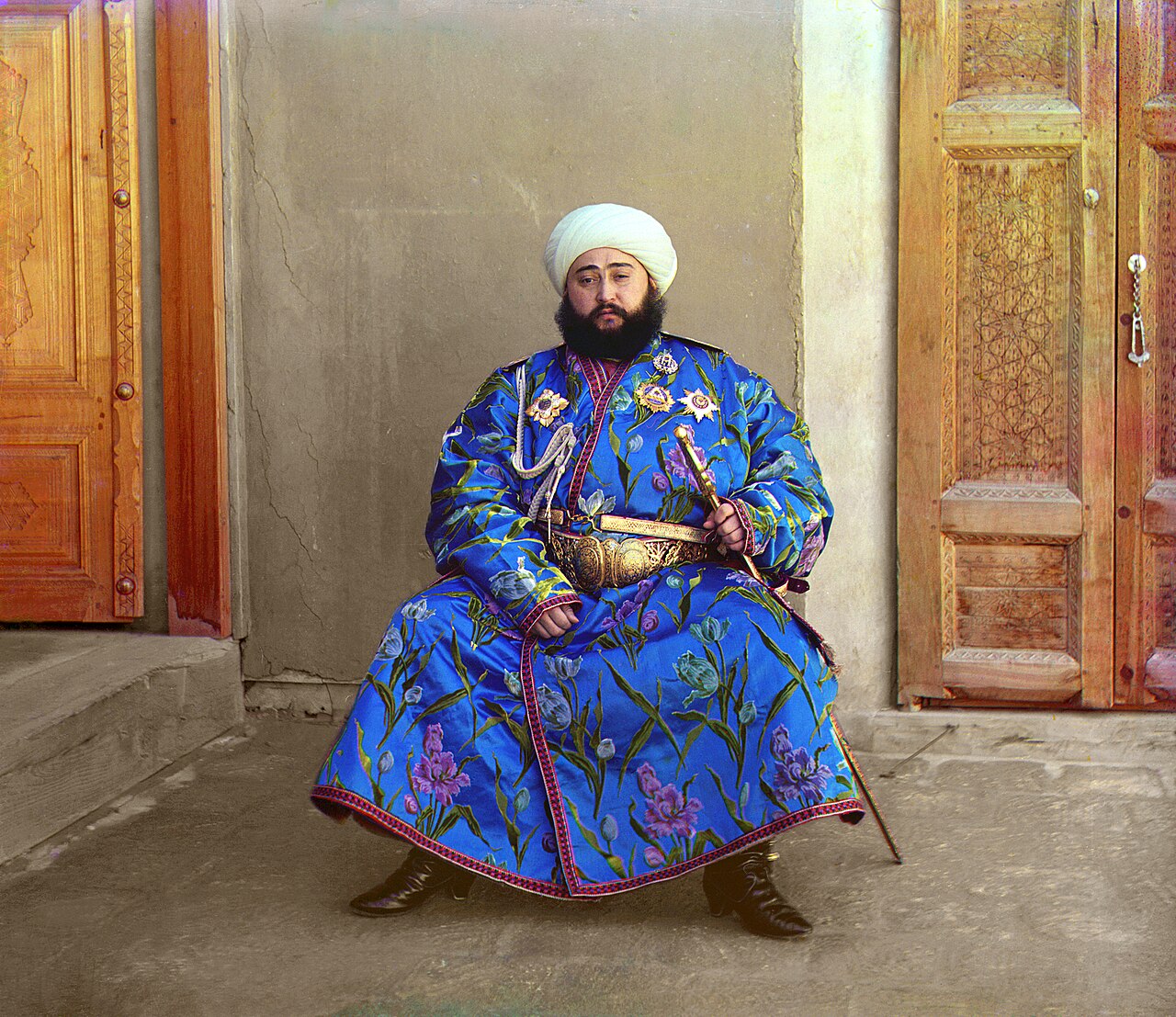
Alim Khan, Emir of Bukhara, 1911.
Maker: Sergei Prokudin-Gorsky · Date: 1911 · Holding source: Library of Congress, Prints and Photographs Division, Prokudin-Gorsky Collection, via Wikimedia Commons — public domain, verified on the file page, 2026-10-28.
What it shows: Said Mir Mohammed Alim Khan, the last Emir of Bukhara, in state dress — the ruler of a functioning court nine years before his emirate fell in 1920 and he fled to Afghanistan, where he died in 1944.
What it does not show: the emirate whole. A throne portrait is a court's presentation of itself; the markets, villages and irrigation works of Bukhara's country stand in other frames of the same collection, not in this one.
A period document: its presentation is its maker's, not today's.
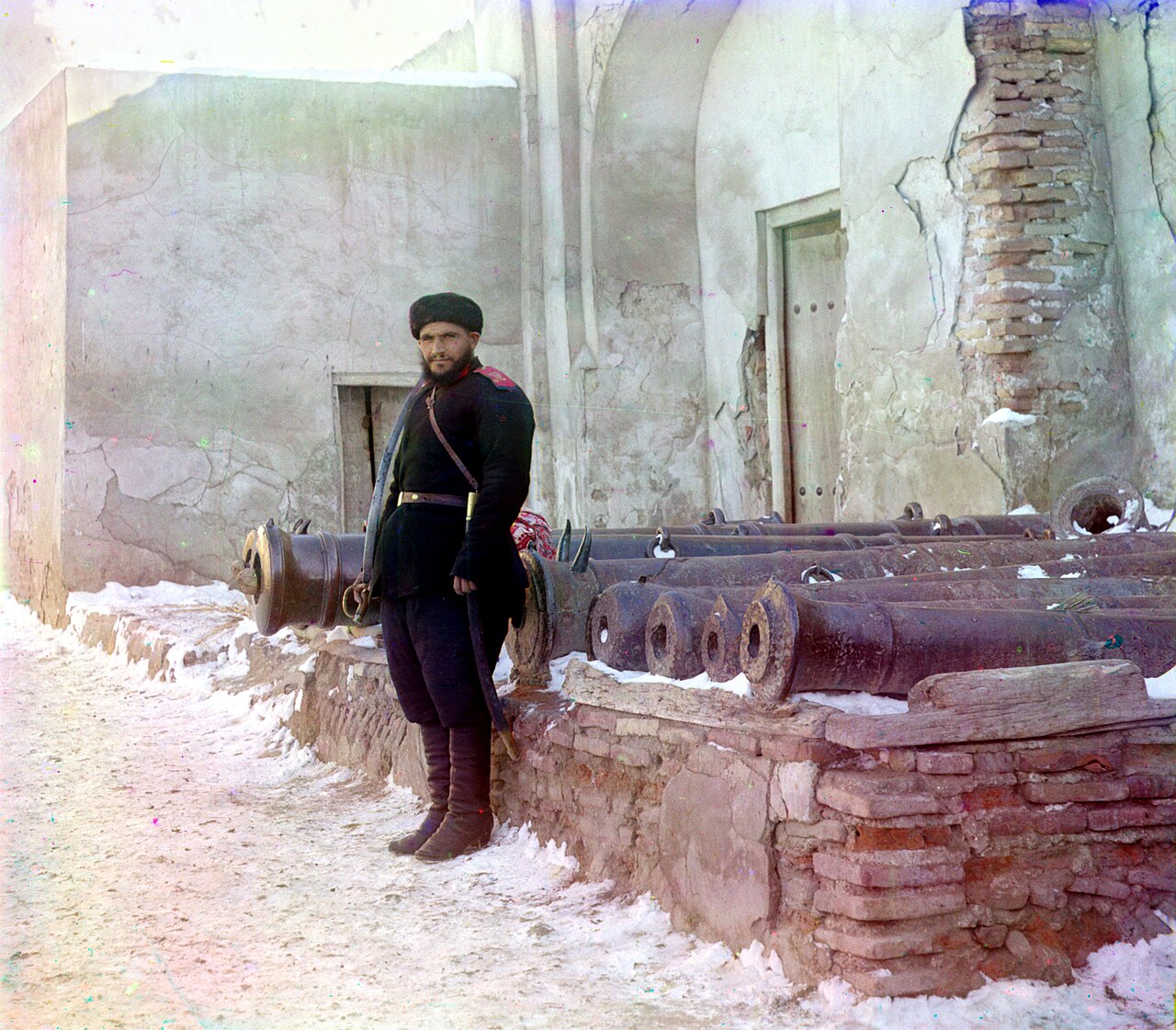
A sentry at the palace, Bukhara, c. 1905–1915.
Maker: Sergei Prokudin-Gorsky · Date: between 1905 and 1915 · Holding source: Library of Congress, Prints and Photographs Division, digital ID prokc.21872, via Wikimedia Commons — public domain, verified on the file page, 2026-10-28.
What it shows: a uniformed sentry of the Emir's guard on duty at the palace at Bukhara, the emirate's old cannon beside him — the ordinary military furniture of a small, real state in its last years.
What it does not show: a power able to stand against the empires around it. By the year of this photograph Bukhara had been a Russian protectorate for four decades; its independence was internal, and ended altogether in 1920.
A period document: its presentation is its maker's, not today's.
§9 — THE GEOGRAPHY BOOKS' TARTARY, IN ITS PLACE
DOCUMENTED — period knowledge, at period weight. What eighteenth-century Europe knew of all this, it knew under one name. The geographical grammar of 1777 gives “TARTARY in ASIA” some 4,000 miles by 2,000 — a period figure — between the Frozen Ocean and China, India, Persia and the Caspian, and divides it five ways: a north-east of Kamchatka, Yakutsk and Bratski peoples; a south-east of Tibet and the Monguls; a north-west of Samoieda and Ostiacks; a south-west of Circassian and Astracan Tartary and Siberia, with Tobolsk its station; and a middle division of Kalmuc and Usbec Tartary, with Bokharia and Samarcand. Its peoples are the wandering Tartars of the spring migrations — bodies of ten thousand moving with their herds, living on a place until its grass was eaten, holding settled labour the greatest slavery, wishing an enemy no worse than that he might “live in one fixed place and work like a Russian”; matchless horsemen from infancy; hospitable, cheerful, fiercely filial; eating smoked horse-flesh; wintering in the far north in huts half sunk underground, whole families joined by passages below the earth — “an invisible city.” Its governments it states exactly: no one government — innumerable tribes under petty khans, choosing a great khan in emergencies who could field, the book says, twenty to three hundred thousand horsemen, his residence itself a movable military station; and the tribes ringed and pressed by the Russian, Chinese, Mogul, Persian and Turkish empires, paying tribute to one or another, some still independent and formidable — particularly, it notes, to the Chinese. Its own history of the region is in the past tense and correctly aimed: Tartary “formerly known by the name of Scythia,” Usbec Tartary “once the seat of a more powerful empire than that of Rome or Greece,” the native country and favourite residence of Zingis Khan and Tamerlane. And it confesses its ignorance on its face: no geographer's account of the region's extent and limits could be depended upon; even the court of Russia did not know its own precise borders there.
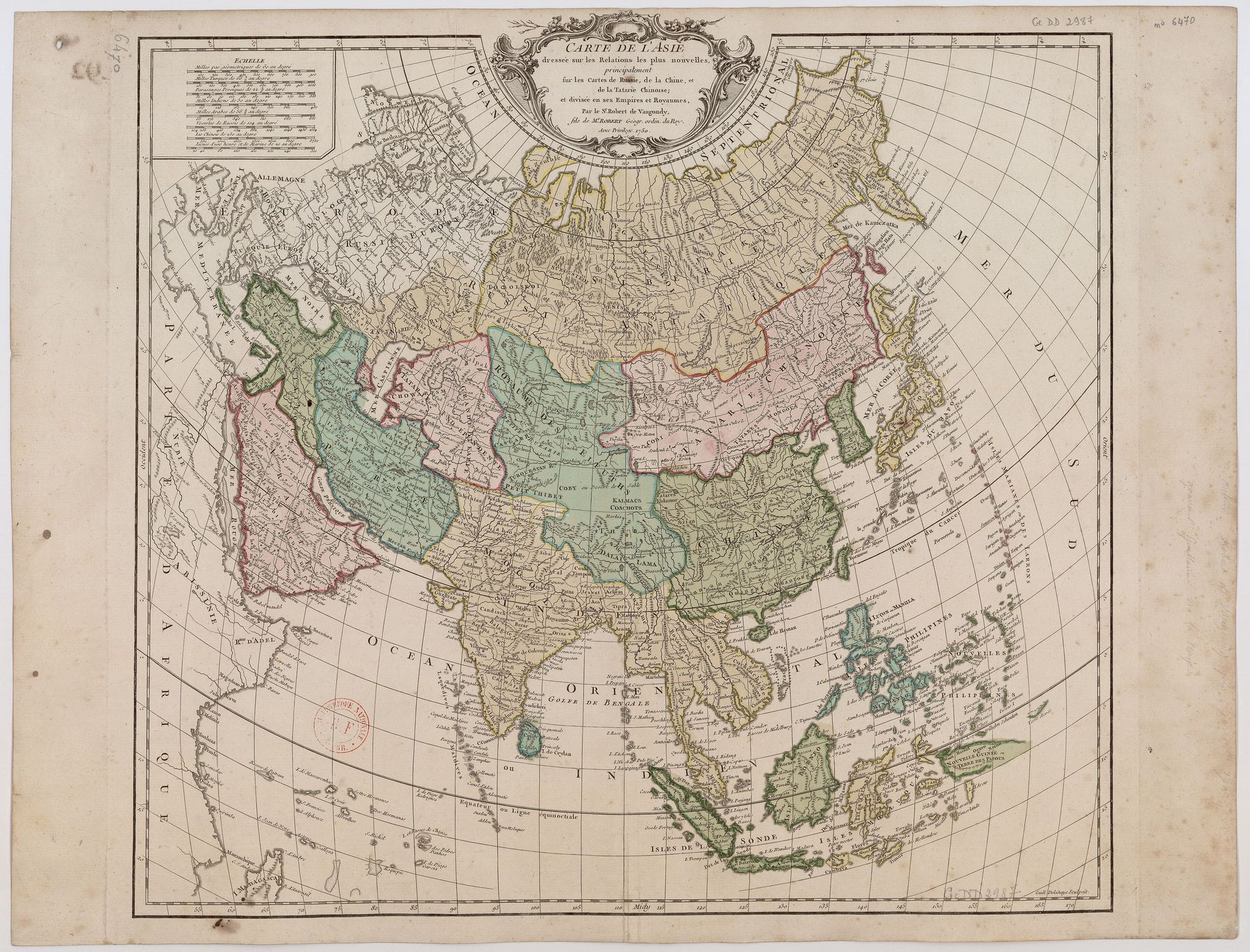
Grande Tartarie across the north, 1757.
Maker: Didier Robert de Vaugondy, engraved by Guillaume-Nicolas Delahaye · Date: Atlas Universel, 1757 (plate drawn c. 1750) · Title: Carte de l’Asie · Holding source: Bibliothèque nationale de France (Gallica, btv1b8592764r), via Wikimedia Commons — public domain, verified on the file page, 2026-10-28.
What it shows: all Asia at mid-century, drawn — its full title says — principally on the maps of Russia, of China, and of Chinese Tartary: GRANDE TARTARIE lettered across the whole north in the French-school manner, over the very world §§2–8 of this class describe.
What it does not show: one Tartarian empire. The broad lettering is a regional label laid over lands the same map subdivides and names severally — Russian provinces, Qing dominions, the independent khanates — and its interior is compilation, not survey: its maker worked in Paris from other men's maps.
A period document: borders and names are its maker's, not today's.
DOCUMENTED. Set in its place, the grammar of 1777 is the record of what Europe knew: right about the life of the steppe in ways Herodotus would have recognised across two thousand years, and blank wherever no traveller had yet gone. It divides Tartary five ways in one article and three ways — Chinese, Russian, Independent — in the gazetteers of the same age, and both filings agree in the only point that matters: the name covered parts held by different powers and peoples, never a single state. The full set of the maps — Ortelius 1570, Delisle 1706, Vaugondy 1757, Cary 1806, each captioned whole — stands on the plate: The Maps of Tartary — Four Period Maps, 1570–1806; the word, the maps line and the word's retirement stand in the companion class, The World of the Maps.
§10 — THE PEOPLES, STANDING
DOCUMENTED. The label is gone from the atlases; the peoples are not gone. The Mongols stand in Mongolia and in Inner Mongolia, among the Buryats of Baikal and the Kalmyks of the Caspian steppe — Oirats who crossed the whole grassland westward in the 1630s and whose khanate stood on the Volga until 1771. The Tatars stand in Tatarstan, whose capital is Kazan, in the Crimea and its diaspora, in Siberia and among the Lipka communities of Poland and Lithuania. The Turkic peoples of the khanates and the open steppe stand in their own states and republics: Kazakhs, Uzbeks, Turkmens, Kyrgyz, Karakalpaks, and the Uyghurs of the Tarim oases; the Tuvans, Yakuts (Sakha), Evenks, Chukchi and the other peoples of Siberia stand in theirs. Their languages, chronicles, music and herds are continuous with the world this class has described — not revived from it, never having left it. A thousand years of peoples on one grassland were never one empire and never one people; what they shared was the grass, the horse, and the long argument with the empires at the grass's edge. The grass is still there. So are they.
Signpost. In modern circulation the name of this world has been carried into a further claim: that a single, advanced, world-spanning Tartarian empire once stood where the maps letter Tartary, and was destroyed and deliberately erased from the record in the eighteenth or nineteenth century. That claim and its testing against the same maps, gazetteers, buildings and archives used in this class stand in the research file named below, and in one section of the companion class, The World of the Maps. The history above is the record that testing rests on; it stands whole, on its own terms, without reference to the claim.
Sources
Period sources named in the text: Herodotus, Histories, Book IV (c. 440 BC) · the Chinese record of the Xiongnu · the Roman record of the Huns · the Orkhon inscriptions (730s) · Giovanni da Pian del Carpine, Historia Mongalorum (1240s) · William of Rubruck, Itinerarium (1250s) · Rashid al-Din, Jami' al-Tawarikh (c. 1300–1310) · Marco Polo's account of the Great Khan's realm (from c. 1300) · Ortelius, Tartariae sive Magni Chami Regni typus (1570), with his Catalogus Auctorum · Robert de Vaugondy, Atlas Universel (1757) · Thomas Salmon, A New Geographical and Historical Grammar (1749), as continued in The New Universal Geographical Grammar (1777), article “TARTARY in ASIA” · the Treaties of Nerchinsk (1689) and Kyakhta (1727) · the Treaty of Gandamian (1873) · Sergei Prokudin-Gorsky, the Central Asia photographs (c. 1905–1915), Library of Congress.
Read beside this class: The World of the Maps — Tartary as the Geography Books Knew It · The Maps of Tartary — Four Period Maps, 1570–1806 · The Mapping of the World · The Chronology — The Whole History in Order of Time.
Record: THE_STEPPE_WORLD_2026-10-28.md (study_materials/world_history), built on tartaria-the-land-and-the-claim.md Part II and Addendum A.4, and TARTARY_AS_THE_GEOGRAPHY_BOOKS_KNEW_IT.md — classes carried unchanged. The maps: MAPS_PROGRAMME_REGISTER_2026-10-28.md, entries H1 and H3.